3-D MODELING

SCOPE OF SERVICE: Using drones and strategic flight plans, iFLiWi can conduct sophisticated aerial 3-D surveys of objects with vertical gradients, processing the results into 3-D digital formats for further customer or iFLiWi post-processing and analysis.
PRACTICAL APPLICATIONS: Virtual real estate tours, architectural design and development modeling, as-built site and systems documentation, traffic or structural accident recording, site walkdowns, virtual gaming asset development, construction preparation/progression/completion documentation, land/water/roof area measurements, volumetric cut-and-fill measurements, structure feature measurement, urban planning, highway planning, golf course planning, mining operations monitoring, forest management, etc.
WHY
iFLiWi 3-D Modeling?
PERSPECTIVE
To provide customers with amazing perspective, iFLiWi can create detailed models that can be manipulated with ease to be viewed from nearly any vantage point.
MEASUREMENTS
To save time in the field and achieve amazing levels of accuracy, iFLiWi can obtain exacting measurements from data sets comprised of millions of points.
VIRTUAL REALITY
To provide customers with realistic models, iFLiWi can create large point clouds coupled to photographic textured layers to produce truly amazing and life-like results!
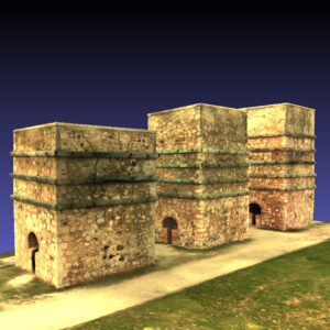
3-D SAMPLE
PARK MODEL
Click left button to grab and spin, scroll wheel to zoom, and right button to grab and pan.
3-D CAPABILITIES & DELIVERABLES
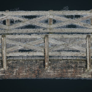
PHOTO-BASED
3-D POINT CLOUDS
Created from dozens, hundreds, or even thousands of relatively low-altitude aerial digital photos, photogrammetry based point clouds are 3-D representations of physical objects formed by hundreds of thousands or millions of points by triangulating features that appear in multiple photographs from different perspectives. iFLiWi can combine this point cloud data with photographic imagery to form remarkable life-like 3-D models of objects and landscapes.
VIRTUAL RESIDENTIAL
3-D LANDSCAPES
As aerial drone photography becomes increasingly more commonplace within real estate markets over the course of the last several years, agents need better ways to set themselves apart as they showcase homes and properties. Through technologies like photogrammetry, iFLiWi can help realtors help their sellers show more properties more quickly while their buyers can enjoy an amazing immersive on-line experience.
AS-BUILT 3-D
DOCUMENTATION
For architects, planners, developers, contractors, and engineers, 3-D photogrammetry models can help record the configuration of structures, whether it be before, during, or after modification. With iFLiWi photogrammetry, customers can save time, save money, reduce errors, while accurately capturing site conditions and equipment dimensions and accurately representing pre-and-post-build configurations.
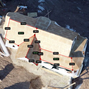
3-D-BASED AREA MEASUREMENT
With the ability to transform a multitude of 2-D images into a single 3-D model, a high level of measurement accuracy can easily be attained through graphical analysis. Rather than spending precious time with tape measures and calculators to quantify work and estimate materials, iFLiWi can make accurate surface area measurements and estimates a breeze, whether the surfaces are sloping rooftops, fragmented parking lots, or disjointed construction sites.
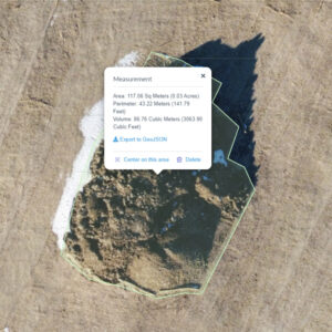
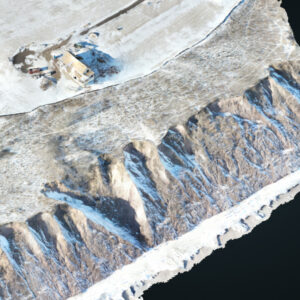
3-D-BASED VOLUME MEASUREMENT
By doing a photogramatric survey and generating a 3-D point cloud, the volume of piles of grain, coal, earth, sand, or aggregate can be measured with great speed and accuracy. With this volume information, construction planning need not be relegated to guesswork, as calculating cut-and-fill volumes makes it much easier to predict the time and resources required to do material addition and removal, allowing contractors to optimize schedules and eliminate unnecessary trips or personnel.

LAYDOWN AREA &
FLOOR PLANNING
While 2-D aerial photographs are obviously useful tools in planning and managing outdoor laydown areas, 3-D photogrammetry can likewise be used in indoor applications, even accounting for vertical sizes and limits. In large and open buildings such as arenas, auditoriums, churches, factories, and retail spaces, iFLWi can navigate interior spaces in order to create a living and working model that can be used for planning structural changes, rearranging equipment, or evaluating layout options.
3D SAMPLE
HOUSE MODEL
Click left button to grab and spin, scroll wheel to zoom, and right button to grab and pan.