SURVEYING & MAPPING

SCOPE OF SERVICE: Using drones and specialized processes, iFLiWi can conduct aerial photographic and marine sonar surveys, processing the imagery for a wide variety of applications by means of specialized software.
PRACTICAL APPLICATIONS: Land surveying, construction progression reporting, erosion monitoring, agriculture monitoring, rooftop measurements, hydrologic modeling, vegetation management, urban planning, soil mapping, highway planning, golf courses, residential development and land use planning, mining, terrain stability studies, silt monitoring, waterway studies, power line monitoring and maintenance planning, etc.
WHY
iFLiWi Drone Surveying & Mapping?
ACCURACY
To provide customers with accurate and precise survey results, iFLiWi utilizes cutting-edge GPS equipment and RTK georeferencing solutions certified and calibrated by NOAA.
SPEED
To provide customers with prompt and expeditious survey results, iFLiWi can work to produce next-day and same-day results, depending upon weather, work scope, lead time, and client requirements.
VERSATILITY
To provide customers with what they want and need, iFLiWi employs a variety of sampling hardware and can process survey results in accordance with industry standards or special customer request.
SAMPLE SURVEY AREA
Click left button to grab and spin, hover cursor and scroll mouse wheel to zoom, and click right button to grab and pan.
SURVEYING CAPABILITIES & DELIVERABLES
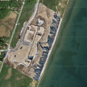
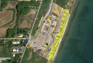
2-D ORTHOMOSAIC
COMPOSITE IMAGES
Stitched together from dozens, hundreds, or even thousands of relatively low-altitude aerial photos, orthomosaic composites are large images similar to but more detailed and accurate than Google satellite image views. Using high centimeter-level accuracy Real Time Kinematic (RTK) GPS equipment and Ground Control Points (CGP’s), iFLiWi can help survey properties from a birds-eye view and capture landscape features and details within inches.
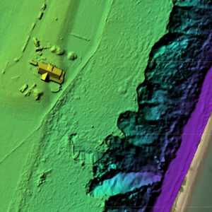
DIGITAL SURFACE MODELS
In addition to high resolution orthomosaic images, iFLiWi can also produce Digital Surface Maps (DSM’s), which may use superimposed color gradients to show elevation of landscape, bodies of water, vegetation, and structures. Unlike ordinary 2-Dimensional orthomosaic images, DSM’s are useful for assessing relative elevations of objects at a glance in order to assess a site for visual or physical obstructions for purposes of design or maintenance.
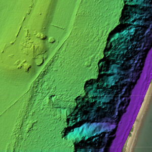
DIGITAL ELEVATION MODELS
Unlike DSM’s, Digital Elevation Models (DEM’s) filter out objects above ground level elevation, such as bridges, roads, vegetation, trees, and man-made buildings and structures to create a ground level map (see yellow house missing from adjacent DSM example). Also referred to as bare earth elevation models (omitting above ground objects), DTM’s are useful in mapping soils, in delineating watersheds, in calculating flow accumulation, and in determining flow direction.

DIGITAL ELEVATION
MODEL
Digital Elevation Model (DEM) files convey elevation data of terrain over a specified area, usually raster layers at a fixed grid interval over the “Bare Earth”. DEM data can be graphically represented in a number of ways, as triangulated elevation data points may be shown as planes or contour lines of constant elevation increments.
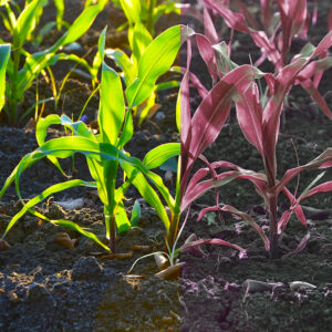
CROP INSPECTION
& HEALTH MAP
By means of specialized camera light filtering and analysis, iFLiWi can deploy drones to monitor plant chlorophyll content based upon reflected light frequencies to help assess the health of plants (e.g., corn, wheat, soybeans, rapeseed, grass, and weeds) and soil conditions (e.g. moisture, nutrients, pests, etc.), typically by means of Normalized Difference Vegetation Index (NDVI) monitoring.

BAthymetric
Depth Map
While water is generally not conducive to creating orthomosaic composite images by means of digital photography, iFLiWi can deploy drones equipped with sonar to survey underwater riverbeds, canal floors, and lake bottoms. Typically, the sonar survey data is paired with GPS position data to obtain a 3-D model of the bottom beneath the surface. and create depth contour maps.
SAMPLE ORTHOMOSAIC PHOTO
Georeferenced TIFF (RTK not employed) – Hover Cursor Over Image and Scroll Mouse Wheel to Zoom or Left Click and Drag Cursor to Move Map
SAMPLE ORTHOMOSAIC DSM
Georeferenced TIFF (RTK not employed) – Hover Cursor Over Image and Scroll Mouse Wheel to Zoom or Left Click and Drag Cursor to Move Map
SAMPLE ORTHOMOSAIC DTM
Georeferenced TIFF (RTK not employed) – Hover Cursor Over Image and Scroll Mouse Wheel to Zoom or Left Click and Drag Cursor to Move Map
SAMPLE SURFACE CONTOUR DEM
Georeferenced TIFF (RTK not employed) – Hover Cursor Over Image and Scroll Mouse Wheel to Zoom or Left Click and Drag Cursor to Move Map