
Survey Your Domain and Make Custom Maps.

Elevate Your Sales & Bottom Line.

Inspect Equipment & Improve Reliability.
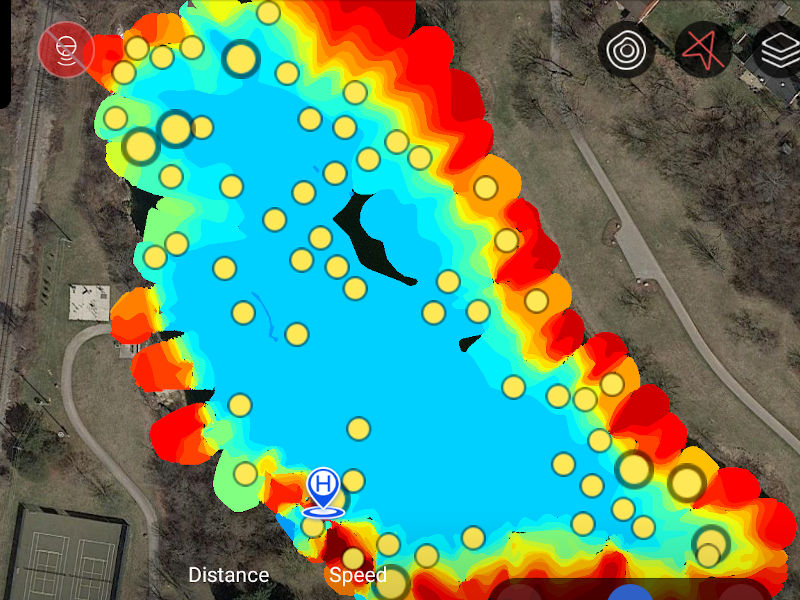
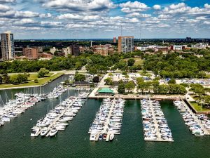
Chart Water Depth, Temperature, & Other Properties

Save Time, Money, Labor & Resources.
Oversee & Manage Projects Remotely.
Evaluate Your Crops & Greens via Infrared.

Show Your House with Sophistication!
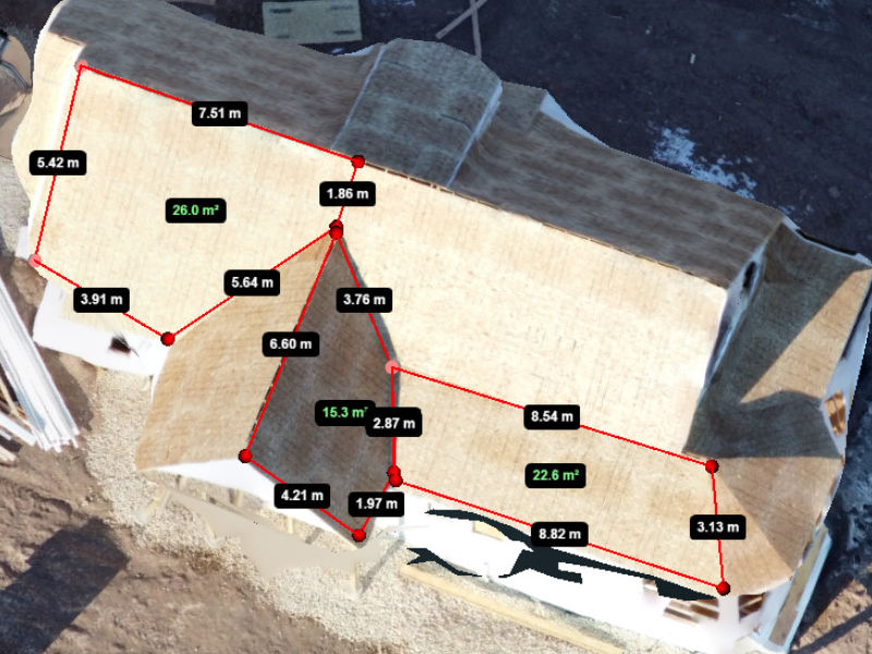
Measure Dimensions & Volumes of Structures & Stockpiles.
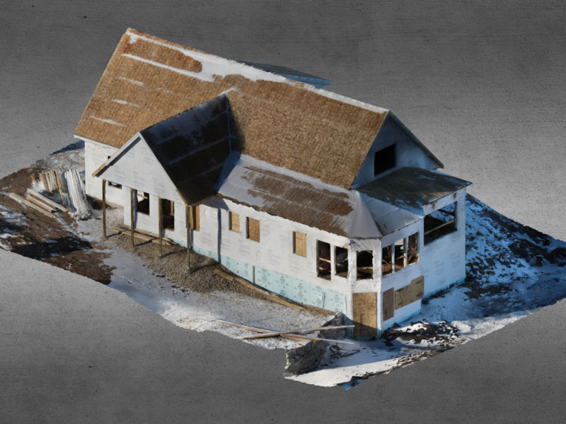
Create 3-D Models from Real-Life Objects.
Capture Your Big Picture Vision!
Share Achievements with Loved Ones!

Minimize Employee Risks & Injuries.
Educate & Inform Your Audience.

Commemorate & Celebrate Life!
BASIC MISSIONS: PILOT SERVICES
iFLiWi works with customers to execute aerial missions that are specifically tailored to your application and business needs, leveraging the latest drone hardware, software, and communications technology.
Aerial Drone Operation
Drones can be used in countless applications, including capturing amazing video and photo content. To safely and legally operate this high-tech gear for commercial and industrial use, iFLiWi is certified per FAA sUAS Part 107 requirements–giving you, your bosses, and your neighbors piece of mind!
Marine Drone Operation
Do you need to inspect something on or beneath the surface, or did you lose something in the water off a pier or boat? If so, iFLiWi can help you see into the abyss by means of camera, sonar, or submersible drone technology, and can even help you recover your valuables once they are located.
Video Streaming
& Proxy Piloting
Why mobilize an entire project team to a job site when you can inspect or view just about any job site, landscape, or equipment from the convenience, comfort, and safety of your home or office? Learn how iFLiWi can stream live a live camera feed taken any vantage point directly to your project team!
ADVANCED MISSIONS: TECHNICAL SERVICES
With advances in computer image processing technology, iFLiWi is helping customers make great strides as they migrate into a world of virtual reality through a variety of 3-D rendering, photogrammetry, virtual reality, and mapping technologies.
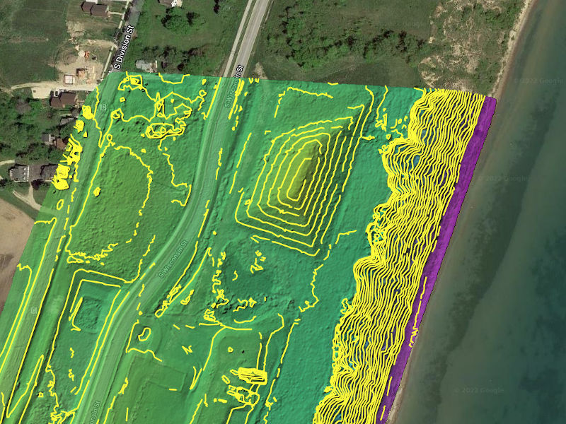
Land Surveying & Site Mapping
Using high accuracy RTK GPS equipment, iFLiWi can conduct aerial surveys of construction sites, residential developments, cityscapes, agricultural fields , and land development projects to create orthomosaic maps, surface elevation and monitor agriculture and job progress, etc.
Aquatic Surveying & Charting
Using the latest sonar equipment and/or underwater camera gear in conjunction with RTK GPS equipment and other instruments, iFLiWi can conduct surface and underwater surveys, create bathymetric maps, sediment surveys, etc.
3D Modeling & Photogrammetry
Do you need an accurate 3D representation of a structure or object for analysis, as-built records, mock-ups, or planned modifications? Rather than modeling objects from scratch or assorted and outdated drawings, iFLiWi can collect 3D point clouds from current real world data to create realistic digital models.
OFFICE MISSIONS: DOCUMENT SERVICES
After the aerial imagery of your people, properties, processes, equipment, or events are recorded, iFLiWi can also perform a wide variety of value-added services, including editorial, data processing, engineering, drawing, and clerical tasks to technically or artistically tailoring your recordings into a more useful format, including a wide range of documents and/or electronic deliverables. With advances in computer image processing technology, iFLiWi is helping customers make great strides as they migrate into a world of virtual reality through a variety of 3-D rendering, photogrammetry, virtual reality, and mapping technologies.
Inspection Results & Reports
Drone-based inspections are useful, but not an end in and of themselves. To help process, document, and contextualize your recordings, iFLiWi can document inspection results, annotating reports with location, ID information, material condition, etc., so your staff can focus on other priorities.
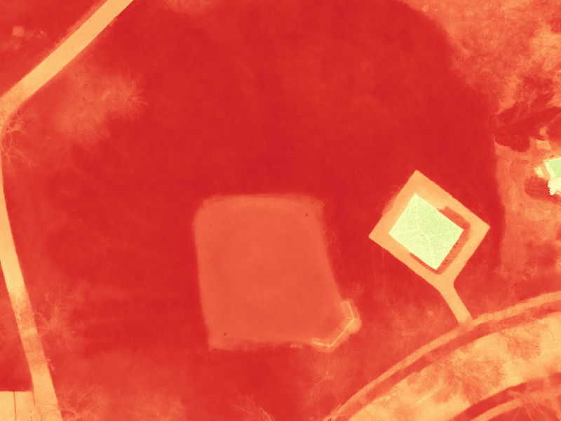
Calc’s, Drawings, Charts & Certification
Using the latest software, iFLiWi can process drone data to obtain sizes, areas, and volumes of structures and piles, accounting for all shapes and irregularities. Likewise, iFLiWi can help transform aerial drone data into scaled drawings and site plans, certifying the drawing content should the need arise.
Engineered & Custom Solutions
Because every customer is different and every job unique, iFLiWi wears more than one hat and provides tailored solutions. Do you need periodic recordings and updates or dispatchable support? Something not advertised or special gear? Tell iFLiWi what you need and iFLiWi will try to work with you!